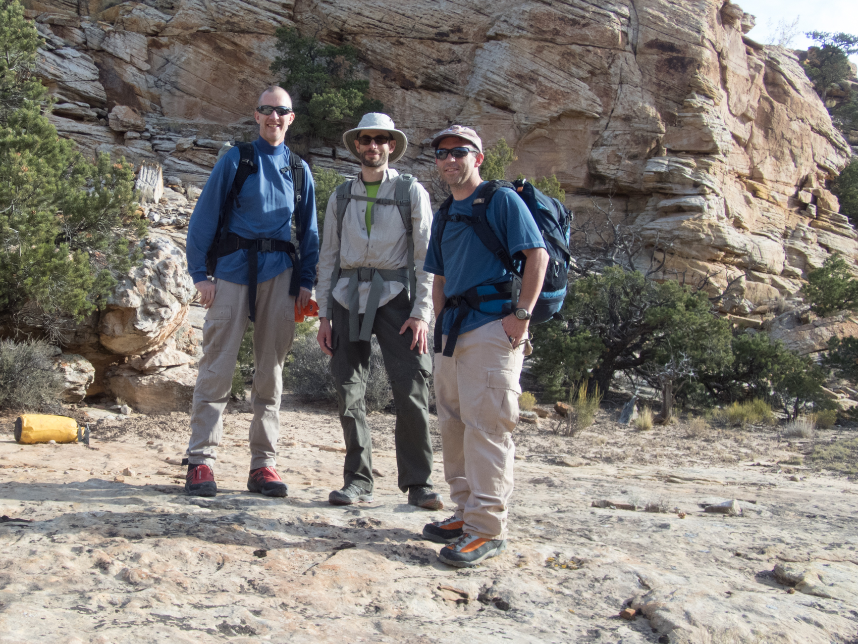
On October 6, 2016, Layne and I headed to southern Utah for our second annual canyoneering trip. This year we were joined by one of Layne’s co-workers, Zach, who would be doing his first technical canyons.
Last year we focused on North Wash, and this year we would be focusing on Robber’s Roost. We had also tried to do Baptist Draw in 2015, but I didn’t take a wetsuit, and we ran into a lot of water, so we ended up turning around and not finishing it. So this year, we were going to take our wetsuits and try Baptist Draw again.
So, Layne and I started driving about mid-day on Thursday. I hate the drive from Alabama to Utah, but there’s no other good way to do a trip like this without driving. Rental car companies won’t let you take their cars off paved roads, and all of the canyons are a long way off paved roads. I know many people ignore those rules, but it’s just not worth the risk to me. Besides, I love my 4Runner, so I just deal with the drive. With two of us, we try to drive as much as possible without stopping, but we usually bottom out somewhere around Kansas and have to stop for a couple of hours. I think in the future we’re just going to stay in a hotel and deal with it…it’s really unpleasant to make that drive without stopping, so I’m trying to figure out how to make it less unpleasant.
Zach had to attend a wedding in Denver the week before the trip, so we picked him up on the way and headed on to Utah.
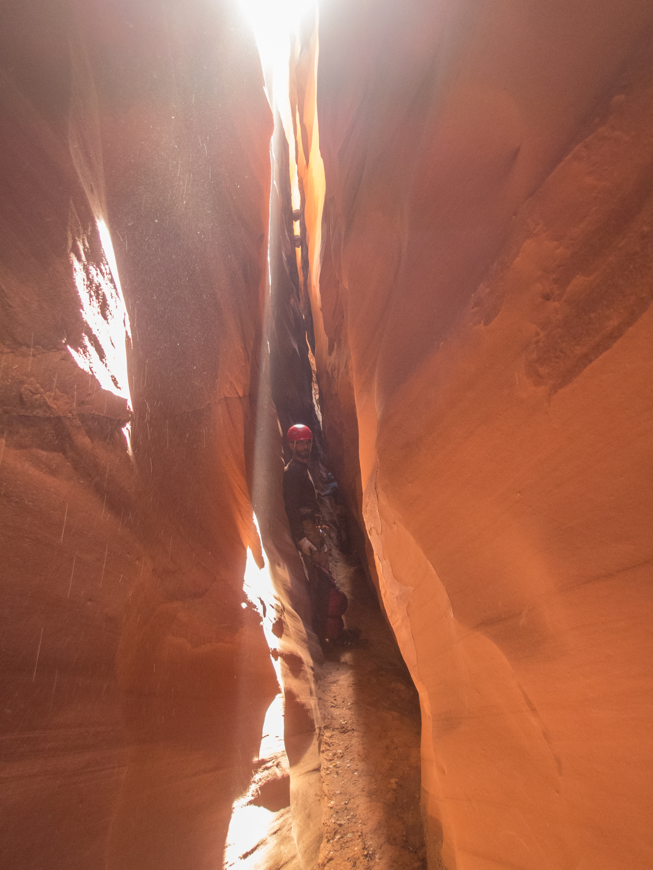 The first stop was Baptist Draw. We arrived at the trailhead pretty late in the evening, so we set up camp and relaxed underneath the beautiful desert sky. The next day we headed down the canyon. There was some water in Baptist, but it wasn’t as deep as the year before. The first pool was at the bottom of the first rappel, and there were a couple of other short, shallow pools in the canyon. Zach waited to put on his wetsuit, so he got pretty cold, but we got him warmed up and continued down canyon. We ran into another group just before the rappel into Chute Canyon, and we rigged the rappel with them and let them use our rope.
The rappel into Chute is really pretty. Once at the bottom, we headed up Chute for the shorter route. This is a pretty route, and we really enjoyed it. There were some narrow slots that made it enjoyable, and then the climb out was very straight-forward. Once on top, we hiked back on the emerging trail back to the truck. We then drove from the Swell over to the Robber’s Roost area and camped above Little White Roost.
The next day we dropped down into Little White Roost. The technical parts of this canyon are pretty short, and there’s only one 83 foot rappel, but it’s a pretty canyon with some tough downclimbs. After a couple of hours, the slots end, and the canyon opens up. This canyon uses an exit in the main fork of White Roost, so we headed down canyon to the confluence of White Roost, and then headed up canyon into White Roost. The exit was easy to find with waypoints in the GPS, but the climb out was steep and long. The best part about the exit was that we knew we intended to do White Roost the next day, and uses the same exit…so we would have to do this climb out twice. But, as always, the views were outstanding and the exit was worth the effort.
 We camped at the same campsite as the night before, and then got up the next morning to do White Roost. We decided to leave the car at the exit and do the hike to the entrance during the cooler temperatures of the early morning. So we did the two mile road walk back to the top of White Roost and then descended down into the canyon. This was another great canyon with some interesting rappels and downclimbs. The last rappel became interesting in a hurry. Our rappel order is almost always Layne, Zach, and then me. This order just sort of developed from when Layne and I went by ourselves and I would keep an eye on the anchors I rigged while he went down, and then the taller person (Layne) could help spot me as I went down last. So, Layne went down the last rappel in White Roost and reported that there was a pretty deep pool at the bottom. So he got off rope and waded to the other end of the pool to get out of the water. Then Zach went down and did the same thing. Then I (the shortest) went down and needed to brace myself awkwardly in the pool to keep from swimming while I pulled the rope. I pulled the rope and then tried to figure out how to get the rope across the pool while also trying to keep my pack above the water. Layne suggested I throw the rope to him because it would float and he could pulled it across. I was cold and wet and an English major talking to an engineer, but I was like, “I don’t think the rope floats.” Despite all of the evidence to the contrary, Layne assured me that it would float and I accepted it and threw the rope out into the pool. Where it immediately sunk.
Huh.
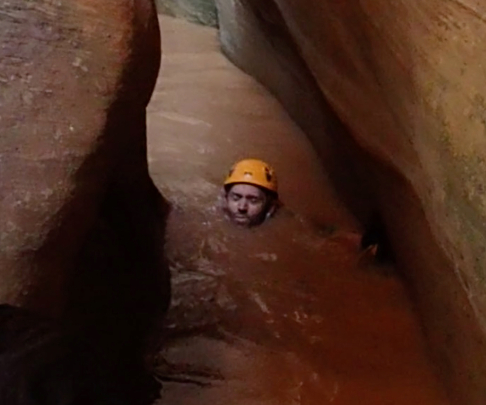 So, I waded out into the pool, where the water reached my chin, and Layne waded out to take my backpack from me, while I tried to find the rope. Luckily, my foot found it pretty quickly, and I was able to grab it and pull it out of the pool. But the moral to this story is: rope doesn’t float. And you can test that theory when you’re in the water and the rope is sitting on the bottom of the pool. Oh well, it only resulted in a funny story, so we sat in the sun drying off for awhile and then continued down canyon to the exit we had used the day before.
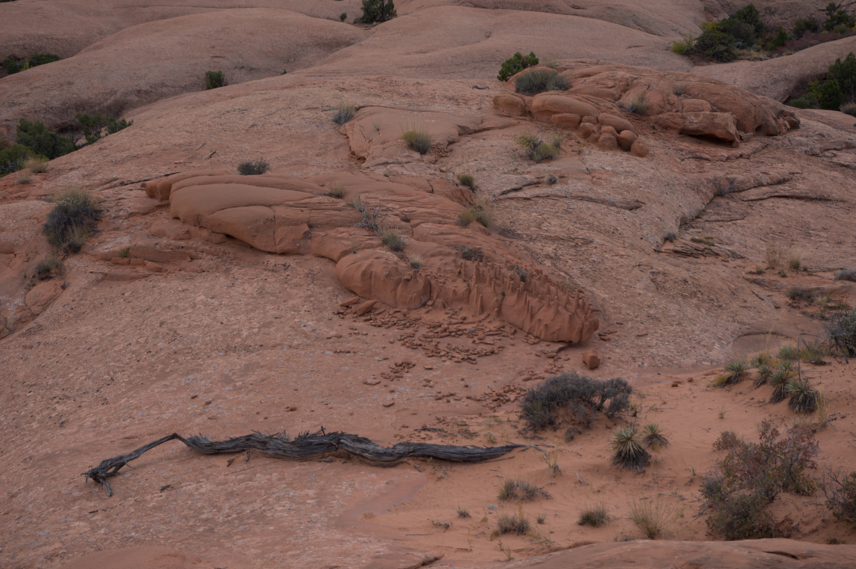
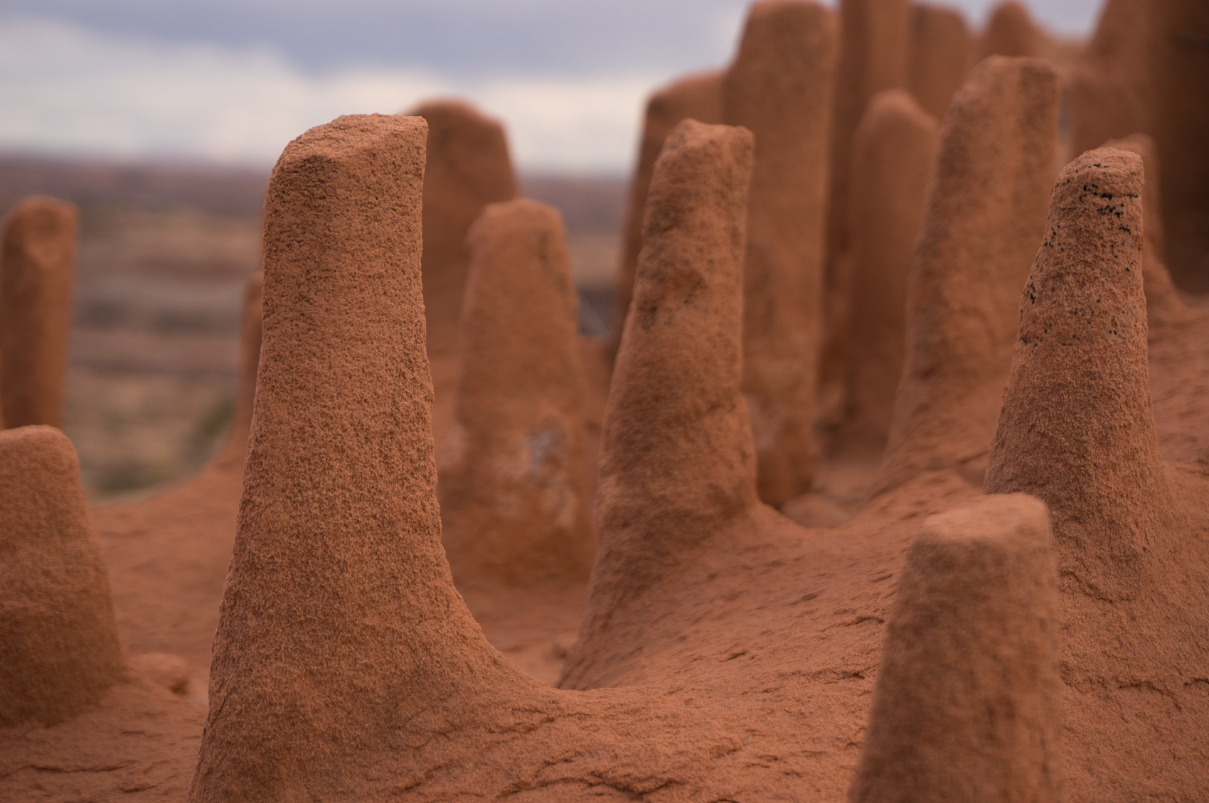
After finishing White Roost, we decided to drive into Hanksville and spend the night in a hotel. We also got the requisite milkshake at Stan’s, which often makes any trip better. The next day we decided to try a relaxing, non-technical day, so we drove out to Moonshine Wash. This canyon is challenging enough to be interesting without any rappels. This canyon helped Zach a lot because he was able to practice stemming and other canyoneering techniques. In hindsight, we probably should have done this canyon first since Zach had never been canyoneering, and it takes practice to learn what you can get away with on slickrock. After a stop at Chaffin Geyser, we drove out to Keg Knoll to camp for the night. It was still early in the evening, so I decided to find the Dragon’s Teeth and Colonnade Arch. I’ve camped at Keg Knoll several times, but somehow I had never been to those attractions.
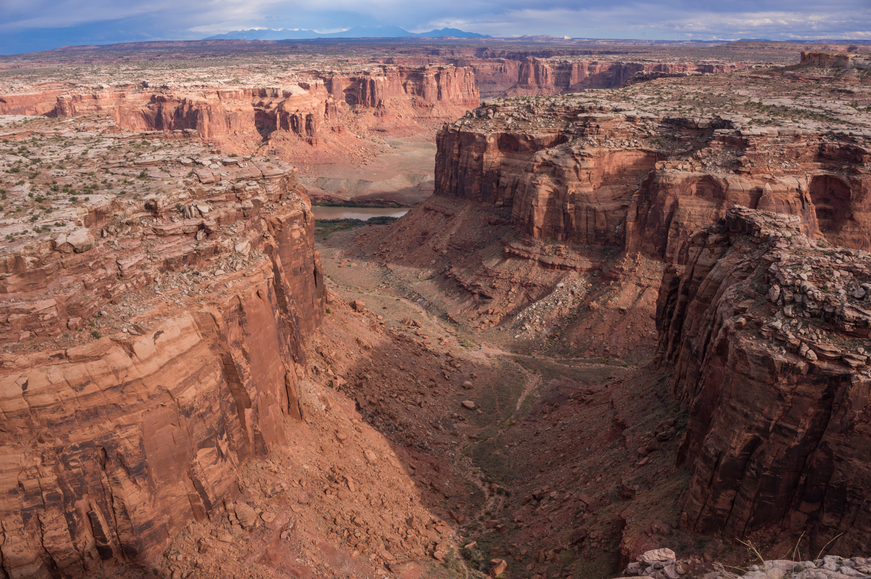
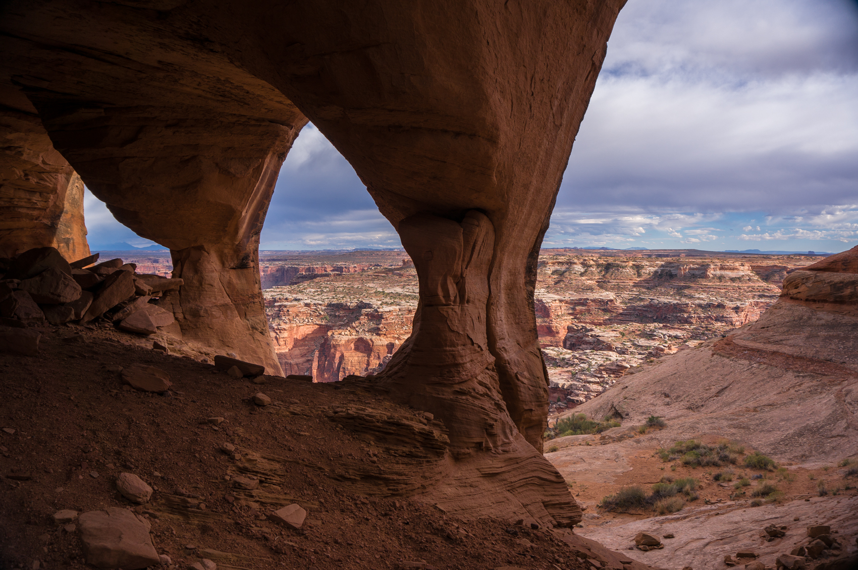 The hike to the Dragon’s Teeth and Colonnade is cross country, with infrequent cairns. Basically, I had waypoints for them and we just navigated our way down to them. The Dragon’s Teeth were interesting, but my pictures weren’t as interesting as I had hoped. Colonnade was amazing, though. The triple arches overlooking Canyonlands and the Green River are just incredible. It was definitely worth the effort, and I’m glad you have to work to get to this view.
We arrived back at the campsite just as the sun was setting. We put up the tents on slickrock just in time for the wind to get nasty. That almost ended in catastrophe when Zach’s tent basically acted like a sail and took off. But we were able to catch it and get it mostly anchored, and everyone survived the night.
 The next day we made the long drive out past Hans Flat towards the High Spur area, where we did the Northwest Fork of Big Spring Canyon. This was supposed to be just a short canyon, but we took longer than planned to do the canyon due to water in the canyon. We tried hard to avoid the pools, which ended up just wasting time, and we still got wet. I have adopted the policy: if you try to avoid water in a canyon, you’re just going to be tired when you get wet. Above one pool, we tried so hard to avoid the water that Layne even re-ascended a drop to rig a longer rope and then he tried to swing above the pool. This resulted in him nearly strangling me when the entire plan was upended by physics. And then when he gave up and dropped into the pool, it was only a few inches deep. Good times. But NW Big Spring was really pretty. The final rappel was open and very nice. On the hike out, I saw my first real rattlesnake in the desert. Layne and Zach had basically walked right by it when I noticed it. That was fun. We then hiked back to the car where my friend, Paul, was waiting on us. Paul had driven from Pueblo to spend a couple of days with us, but he had forgotten to get gas before he headed into the desert. He was running on fumes and about as far away as you could possibly be from a gas station. So we drove a short distance above Big Spring to a great campsite and settled in for the night.
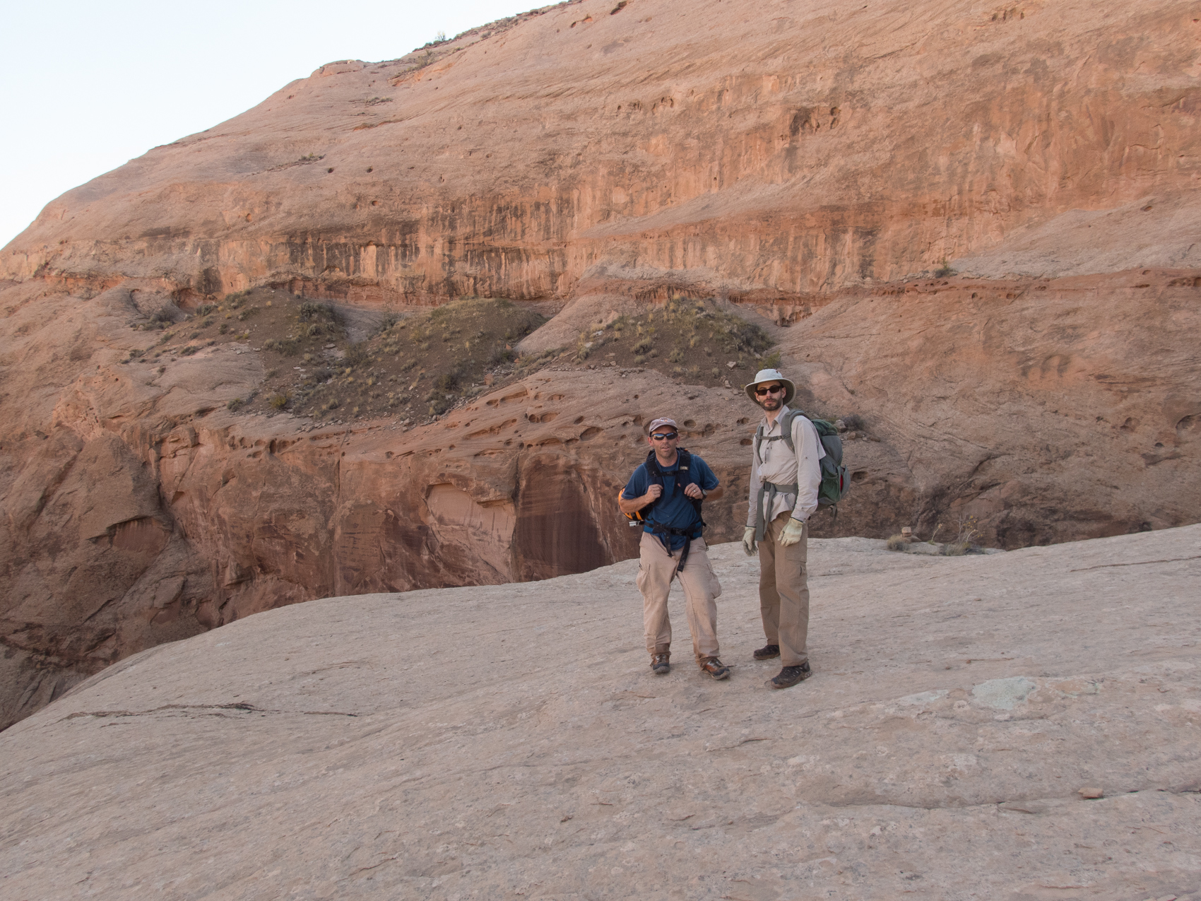
 The next day we did High Spur. We tried to drive Paul’s truck to the exit so we could spot a car there, but he couldn’t make it all the way due to sand. So we left his truck at the sand spot at the top of a slickrock pass, and headed back down to the trailhead. High Spur is an absolutely amazing canyon. It’s a lot of work to get there, and it’s hard to imagine a more remote area, but the canyon is worth all of the effort. The canyon is pretty straightforward, with only two rappels, but the slots are just very pretty. This was Paul’s first canyon, and it was a good introduction to canyoneering. The hike out was long, since we didn’t have the truck at the exit, but it wasn’t too bad. After leaving High Spur, we made the long drive out to Larry Canyon. We decided to give Paul our three gallons of emergency gas, in hopes that he would be able to make it back to town when we were done. We camped that night in the wash at the top of Larry Canyon.
The next morning, Paul and I took his truck to the exit of Larry Canyon, since it’s like a four mile road walk between the entrance and exit. We then returned to the trailhead and headed down Larry for our final canyon of the trip. Larry Canyon turned out to be the highlight of the trip. The first rappel comes up very soon after starting the hike, and it was just gorgeous…and it kept getting better. Some of the rappels were tight and corkscrewed, which was very fun, and there were lots of interesting downclimbs and tight slots. We met another group of three in this canyon, and we pretty much just leap-frogged with them down the canyon all day, sometimes using our rope and sometimes using theirs…it saved both groups a lot of time with rigging the rappels. The beta said that the final rappel could be avoided by an easy walk around the rim on the left. I tried that, and truly thought I was going to slide off the side of the canyon and die. I don’t know where the route is to avoid the rappel, but I firmly believe that the rappel is much safer than the slabby rocks on the canyon wall. We did have to re-rig the anchor for the rappel because the webbing was old, but we eventually got that done and made the beautiful final drop in Larry.
 From the rappel, there was a pretty long hike to the exit. The other group did not have a car spotted at the exit, so they were trying hard to catch up to us so they could ride with us back to the trailhead. The exit crack required some pretty exposed class 4 climbing, and looked totally impossible from the canyon floor. But we managed it without any major drama, and then it was just a very long and very steep climb out on the slickrock, which was made more interesting by 40-50 MPH winds. There were times that all three of us literally had to face plant ourselves on the slickrock to avoid being blown off the canyon. That was actually pretty fun. We then reached the top and waited on the people behind us to catch up. They actually thought we might leave them, so they were practically running up that crazy ascent! But we made it back to the trailhead, picked up my truck, and started back to Green River. I decided to take the Lower San Rafael Road back to town since it was a straighter route and it would force Paul to drive slower than the highway…we really didn’t think he would make it back on the gas he had. But somehow he puttered in to Green River on fumes and another great canyoneering trip had come to an end. We had dinner at Ray’s and then drove to Rifle to see Megan and Jason, before making the long, painful drive back to Alabama.
As always, southern Utah did not disappoint. In fact, I’m falling in love more with the desert now than I did when I lived in Utah. I think the short weekend trips never really put the hook in me, but these longer trips are making me appreciate the desert more. There’s no doubt: I love these canyoneering trips.


[mapsmarker marker=”103″]